Oregon® 700
$599.00
Rugged GPS/GLONASS Handheld with Built-in Wi-Fi® and More
- High-sensitivity dual GPS and GLONASS satellite reception for better performance in challenging environments than GPS alone
- Redesigned antenna enables better reception and performance; 3-axis compass with accelerometer and barometric altimeter sensors
- 3-inch sunlight-readable touchscreen with dual orientation (landscape or portrait view)
- Expanded wireless connectivity (Wi-Fi, Bluetooth®, ANT+® capable); supports Active Weather and Geocaching Live
- Bluetooth®-enabled smart notifications¹ and automatic uploads to Garmin Connect™ online community

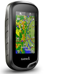
Thanks to a redesigned antenna for better satellite reception, the Oregon 700 GPS and GLONASS handheld puts even more of the great outdoors at your fingertips. Whether you’re hiking, hunting, climbing, kayaking, trail riding or whatever, this rugged navigator is ready for anything. It features multilink wireless connectivity (Wi-Fi, Bluetooth and ANT+), Active Weather support with animated radar overlays, a 1-year BirdsEye Satellite Imagery subscription and a built-in 3-axis compass with barometric altimeter.
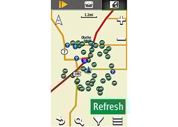
Find Fun with Geocaching.com
The wireless Wi-Fi link and Bluetooth links on your Oregon 700 makes it easier than ever to enjoy a superior geocaching experience. You can set your device to automatically stay up to date with all the latest caches from Geocaching.com. No more manual entry of coordinates or printing out cache details on paper.
More Connectivity, Less Complexity
The expanded wireless capabilities of Oregon 700 make it easier than ever to download software, receive smart notifications¹ and upload adventures to our Garmin Connect online community. You can even share LiveTrack location data or geocache discoveries, unit-to-unit, with other compatible Garmin handheld devices. Smart notifications via Bluetooth connectivity with a compatible smartphone let you receive emails, texts and alerts right on your device. So you can see what’s going on while you’re getting away from it all.
Navigate Your Way
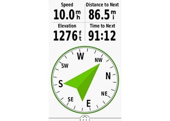
The Oregon 700 handheld provides comprehensive navigation and tracking to guide you on and off the beaten path, using GPS and GLONASS plus ABC (altimeter, barometer and compass) sensor capabilities. The built-in altimeter provides elevation data to accurately monitor ascent and descent, while the barometer can be used to predict weather changes by showing short-term trends in air pressure. The 3-axis electronic compass keeps your bearing, whether you’re moving or not. There’s also a TracBack® feature on Oregon 700 to help you navigate back to your starting point the same way you came. You can also mark locations, such as your campsite, vehicle or other points of interest, to which you’d like return navigation.
Enjoy the View on a Vivid Display
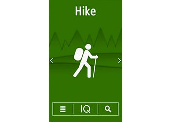
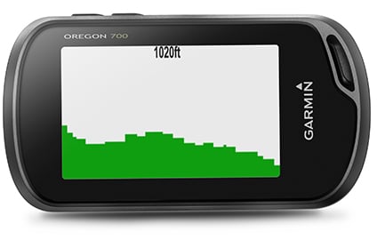
The Oregon 700 handheld features a bright, sunlight-readable 3-inch color touchscreen display with dual orientation for landscape or portrait views. It easily supports multiple mapping options such as BlueChart® g2 HD for water navigation or City Navigator AU/NZ for turn-by-turn driving directions. Durable and water-rated to IPX7, the Oregon series is built to keep delivering vital mapping and tracking data, no matter what the elements throw at you. Plus, you can even customize your Oregon’s display with free downloads of apps, widgets and data fields from the Garmin Connect IQ™ online store².
Plan Your Next Trip
Take charge of your next adventure with BaseCamp™, software that lets you view and organize maps, waypoints, routes and tracks. This free trip-planning software even allows you to create Garmin Adventures that you can share with friends, family or fellow explorers online. BaseCamp displays on your computer screen any topographic map data stored on the device, including contour lines and elevation profiles. It also can transfer an unlimited amount of satellite images to your device when paired with a BirdsEye Satellite Imagery subscription.
Add to quote
IN THE BOX
- Oregon 700
- USB cable
- Carabiner clip
- Documentation
| Physical Dimensions: | 2.4" x 4.5" x 1.3" (6.1 x 11.4 x 3.3 cm) |
| Touchscreen: | Yes |
| Display Size: | 1.5"W x 2.5"H (3.8 x 6.3 cm); 3" diag (7.6 cm) |
| Display Resolution: | 240 x 400 pixels |
| Display Type: | transflective color TFT touchscreen |
| Weight: | 7.4 oz (209.8 g) with batteries |
| Battery Type: | 2 AA batteries (not included); NiMH or Lithium recommended, rechargeable NiMH pack (optional) |
| Battery Life: | up to 16 hours |
| Water Rating: | IPX7 |
| High-Sensitivity Receiver: | Yes |
| Interface: | high speed mini USB and NMEA 0183 compatible |
| Memory/History: | 3.4 GB |
| Maps & Memory: | |
| Ability To Add Maps: | Yes |
| Basemap: | Yes |
| Automatic Routing : | Yes (with optional mapping for detailed roads) (Turn By Turn Routing On Roads) |
| Map Segments: | 15000 |
| Birdseye: | 250 BirdsEye Imagery files |
| Includes Detailed Hydrographic Features : | no (additional mapping needed) (Coastlines, Lake/River Shorelines, Wetlands And Perennial And Seasonal Streams) |
| Includes Searchable Points Of Interests : | no (additional mapping needed) (Parks, Campgrounds, Scenic Lookouts And Picnic Sites) |
| Displays National, State And Local Parks, Forests, And Wilderness Areas: | no (additional mapping needed) |
| External Memory Storage: | yes (32 GB max microSD™ card) |
| Waypoints/Favorites/Locations: | 10000 |
| Tracks: | 250 |
| Track Log: | 20000 points, 250 saved tracks |
| Routes: | 250, 250 points per route; 50 points auto routing |
| Sensors: | |
| GPS: | Yes |
| Glonass: | Yes |
| Barometric Altimeter: | Yes |
| Compass: | Yes (tilt-compensated 3-axis) |
| GPS Compass (While Moving): | Yes |
| Daily Smart Features: | |
| Connect IQ™ : | Yes (Downloadable Watch Faces, Data Fields, Widgets And Apps) |
| Smart Notifications On Handheld: | Yes |
| Virb® Remote: | Yes |
| Pairs With Garmin Connect™ Mobile: | Yes |
| Active Weather: | Yes |
| Safety and Tracking Features: | |
| Livetrack: | Yes |
| Outdoor Recreation: | |
| Point-To-Point Navigation: | Yes |
| Compatible With Basecamp™: | Yes |
| Area Calculation: | Yes |
| Hunt/Fish Calendar: | Yes |
| Sun And Moon Information: | Yes |
| Xero™ Locations: | Yes |
| Geocaching-Friendly: | yes (Geocache Live) |
| Custom Maps Compatible: | yes (500 custom map tiles) |
| Picture Viewer: | Yes |
| Connections: | |
| Wireless Connectivity: | yes (Wi-Fi®, BLUETOOTH®, ANT+®) |