More Detail
Additional product information
ISBN:
9.78E+12
Size:
296mm x 210mm
Binding:
Staple bound
Publication Date:
2007
Author and/or publisher
Spatial Vision
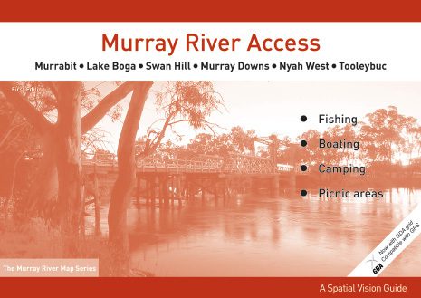
Murray River Access Map – Murrabit to Tooleybuc
$8.95
- Sales Ends In:
Murrabit – Lake Boga – Swan Hill – Murray Downs – Nyah West – Tooleybuc.
Book of detailed forest maps from Murrabit to Tooleybuc showing forests access tracks, camping areas, beaches, boat ramps etc.Now with GDA and compatable with GPS. Featuring Murphy’s Island, Nyah State Forest, Wood Wood, Vinifera River Reserve, Speewa Island, Tyntynder, Beverford, Beveridge Island, Speewa Island, Pental Island, Little Murray River, The Loddon Floodway, Benjeroop Weir, Murrabit West.
Only 2 left in stock
- Spend $100 or more to receive Free Shipping
Secure Payment Options :
Product Specifications
ISBN:
9.78E+12
Size:
296mm x 210mm
Binding:
Staple bound
Publication Date:
2007
Author and/or publisher
Spatial Vision
Customer Reviews
You must be logged in to post a review.
Related Product
$899.95 Original price was: $899.95.$540.00Current price is: $540.00.
$329.99 – $359.99Price range: $329.99 through $359.99
$12.95
$1,169.95 – $1,239.95Price range: $1,169.95 through $1,239.95
$10.00 – $15.00Price range: $10.00 through $15.00
$1,119.95 – $1,159.95Price range: $1,119.95 through $1,159.95

$4.99 – $11.99Price range: $4.99 through $11.99
$3.99 – $4.99Price range: $3.99 through $4.99
$34.95
$39.99


Reviews
There are no reviews yet.